About the Crop Monitors
The Crop Monitors were designed to provide a public good of open, timely, science-driven information on crop conditions in support of market transparency for the G20 Agricultural Market Information System (AMIS). Reflecting an international, multi-source, consensus assessment of crop growing conditions, status, and agro-climatic factors likely to impact global production, focusing on the major producing and trading countries for the four primary crops monitored by AMIS (wheat, maize, rice, and soybeans). The Crop Monitor for AMIS brings together over 40 partners from national, regional (i.e. sub-continental), and global monitoring systems, space agencies, agriculture organizations and universities.
Since its launch in September 2013, the Crop Monitor for AMIS has grown extensively and has become an internationally recognized source of information on global crop prospects, widely quoted by public and private agencies as well as top tier media. It represents the first time that the international community comes together on a monthly basis to produce joint crop assessments.


In line with the goals of the GEOGLAM initiative, the Crop Monitor methods were then adapted and applied to countries at risk of food production shortfalls. The need for an assessment that is prepared horizontally by different international, regional, and national agencies, with overlapping regions, is fundamental in unstable and fragile countries where food security is extremely vulnerable. The success or the failure of a crop for such countries sometimes mean famines, political unrest and the need to import from other countries. These countries, which principally complement geographically the large market producers, are monitored and reported on in the Crop Monitor for Early Warning (CM4EW) reports.
Operational since February 2016, the CM4EW has become an internationally recognized source of reliable information on early warning and crop conditions, and often used to inform humanitarian organization decisions on food allocation and assistance. Through collaborating with the main international humanitarian agencies, regional bodies, and national agencies, the CM4EW has been able to provide timely and accurate on the ground information before humanitarian crises arise.
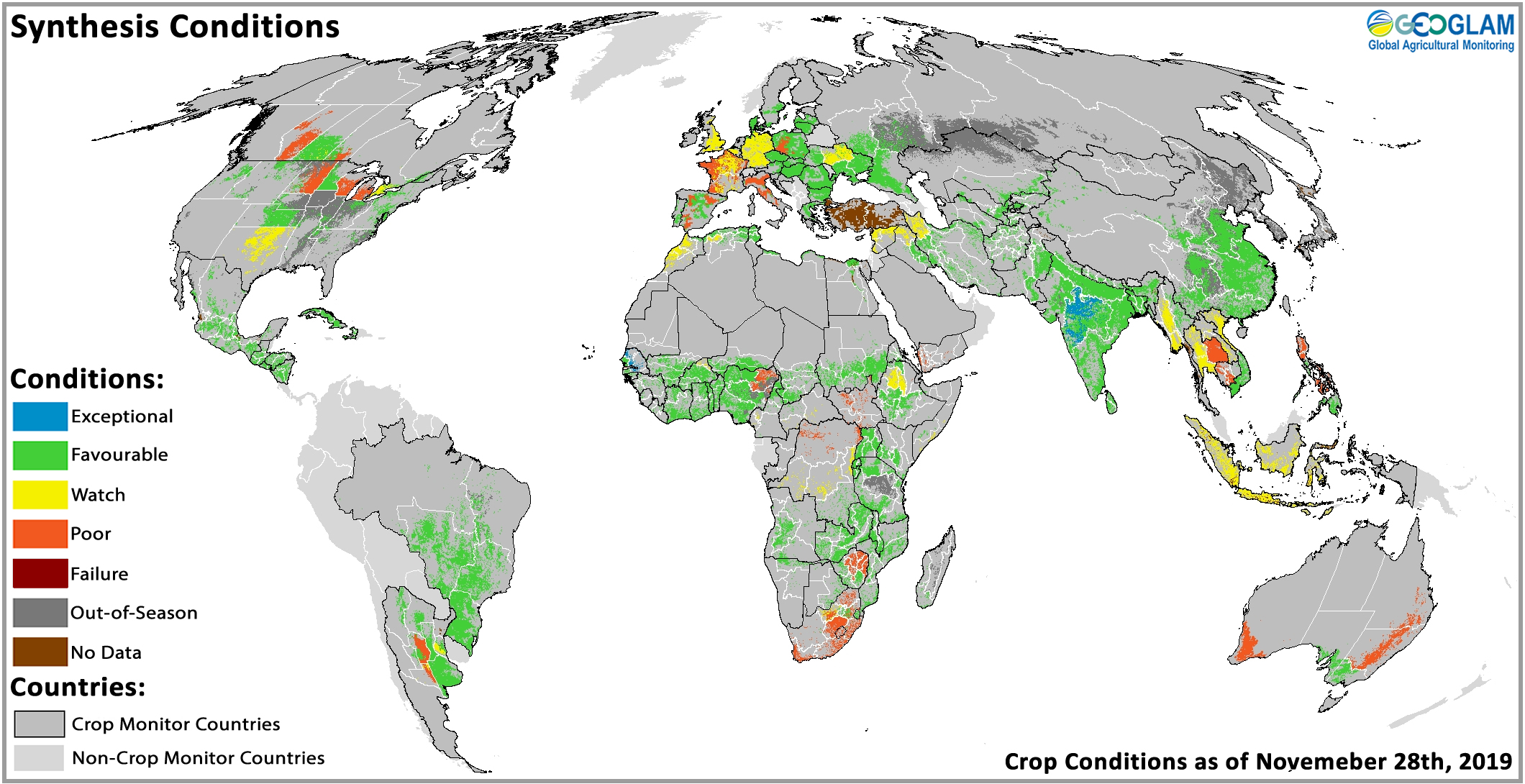
Combined crop conditions across both the Crop Monitor for AMIS and Crop Monitor for Early Warning as of November 28, 2019.
Building on the success of the two global Crop Monitors, GEOGLAM began working with mandated national agencies responsible for food security policy and response programs. The result has been several examples of co-developed Crop Monitors at the national and regional levels. These monitors are developed and operated by the countries close to the program and policy decision-makers. As a result, the information produced is trusted and deemed authoritative; allowing it to be quickly turned into proactive decisions that impact lives and livelihood, while reducing the cost of emergency response.
Beyond national impact, the national and regional crop monitors play a significant role in improving the quality of the global crop monitors for AMIS and the Crop Monitor for Early Warning by supplementing global top-down data flows with bottom-up national-level data. The result is better resolution and accuracy due to better in-situ information and expertise input into the monitors.
Referenced Papers
The GEOGLAM Crop Monitor for AMIS: Assessing Crop Conditions in the Context of Global Markets